GEM/4.6/Changes on horizontal gird
| ||||||||||||||||||||||||||||||||||||||||||||||||||||||||||||||
For the LAM only.
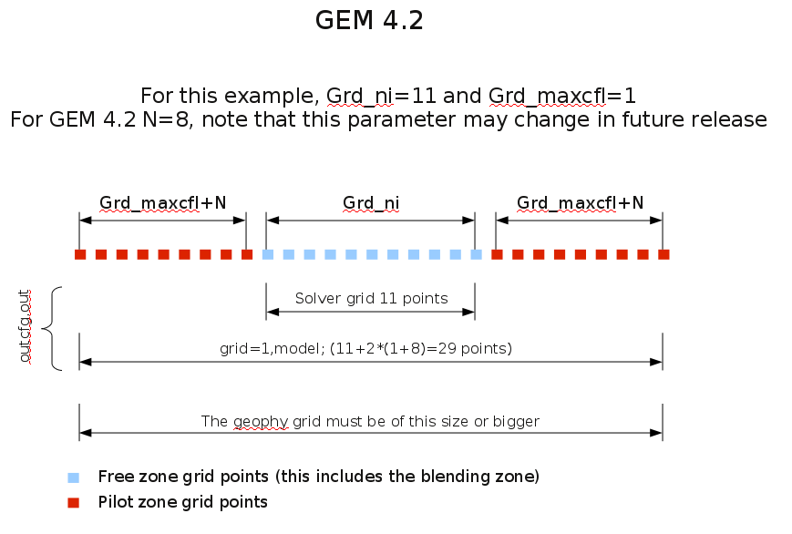
Refer to the figure below. In GEM 4.2 and up, the size of the free
domain (blue squares in figure) will be Grd_ni x Grd_nj regardless of
the Grd_maxcfl parameter. On the other hand, the total size of the grid
including the pilot zones (blue+red squares in figure) will change with
Grd_maxcfl. Therefore if one increase Grd_maxcfl, the geophysical field
may become too small. It may be a good idea to produce your geophysical
field with a large value of Grd_maxcfl than the one you intent to use.
This will leave some room if it is found that a larger Grd_maxcfl is
needed. There will be no interpolation error since the model will detect
that its grid is a sub domain of the geophysical field grid and will
use the closest neighbor interpolation degree.
To convert from a previous gem_settings.nml use the following equations
Grd_ni   = Grd_ni_OLD   - 2*(Grd_maxcfl+8)
Grd_nj   = Grd_nj_OLD   - 2*(Grd_maxcfl+8)
Grd_iref = Grd_iref_OLD -   (Grd_maxcfl+8)
Grd_jref = Grd_jref_OLD -   (Grd_maxcfl+8)
Note : in GEM 4 listing, the OLD values will be printed.
Use the tool grille to view your grid.
| ||||||||||||||
